Offline GPS loggers
The use of Offline GPS loggers is limited by Cocom restrictions placed on GPS devices not to operate over 18km above sea level. This does, however offer opportunities to use the device on smaller weight weather balloons. For technical details on which GPS modules can be used above this height go to http://ukhas.org.uk/guides:gps_modules .
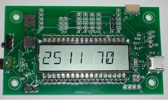
Hexpert Zlog 7 http://www.hexpertsystems.com/zlog/Z7/
The ZLog-7 module is specifically designed to measure and record data in high-altitude (near-space) experiments. A precision sensor measures atmospheric pressure and onboard temperature. A remote sensor measures outside temperature. The board will also record battery voltage and GPS data up to the altitudes reached by high altitude balloons. All data is recorded on commercially available microSD flash cards and can be download for analysis on a PC. The unit is powered by a standard 9v battery with, from full, usually lasts 2 flights.
My experience of the Zlog 7 is a good one. It is very easy to start, it reliably records the GPS, temperature, and pressure data, and it is easy to transfer the data to a laptop or PC afterwards. The free software from Hexpert also allows you to simply transfer the resultant excel file into a Google Earth map to view the flight in 3D. The output data was not without some gaps but this did not distract greatly from the output image. At the time of purchase in early 2013, it was a value product at £110. It may now be superseded by the HABduino if that performs to expectation.
GT-750 tracker April 2013
http://www.conrad.com/ce/en/product/372738/GT-750-Blueooth-GPS-Data-Logger
Lightweight, wireless GPS Logger with Bluetooth® transmission technology and manifold usage possibilities. It can be used with your tablet, smartphone and notebook. You can bring it also along on your hiking tour and can pursue and/or document the route covered once again at home on the computer. The battery lasts up to approx. 13 hours.
Features
- Data storage to the storage of up to 256,000 way points
- Support of WAAS and EGNOS for greater accuracy
- Fully compatible with Bluetooth® V1.2
- A-GPS (Assisted Global Positioning System) compatible.
- Reception of up to 65 satellites It can also be used as GPS-mouse for laptops
The GT 750 was used by Luca Schmid to log the flight path of a HAB. Luca said, “The GPS Logger is really easy to use, you just need to configurate the thing once and after that it will log always if turned on. The porduct is called “GT-750 GPS-Logger” and you can buy it at the conrad web-shop.”
On the first try I reached 28’500 meters, on the second 30’412 meters.
I-gotU GT120 and 200 – 9th January 2013
I-gotU is a GPS Logger and Receiver 2-in-1 device including user-friendly Travel Blog Software. i-gotU records trip routes, Auto-adds photo GPS locations, creates an animated trip journal that brings back live trip memory by plotting the route and playing back the photos / YouTube videos with the exact location on 3D maps, making it more fun and easier to share trip or outdoor sport activities with friends through @trip travel-blog hosting site, Internet Explorer MHTML or Google KMZ file format or popular web album Picasa & Flickr.
i-gotU is compatible with all digital cameras & camera phones. Being the smallest, the lightest, excellent water-resistance of its kind, plus the user definable smart power-saving mechanism, i-gotU is the coolest GPS tracking gadget for your outdoor activities and long holidays.
I-got U offers the opportunity to pack a simple and light offline GPS data logger into your payload to record the balloon height; a feature not offered by enhanced GPS units or personal GPS beacons. The logger ways a little less than 30g.
Balloon News field tested the GT120 on the recent balloon launch of Ivan Fariñas Soto in Vigo, Spain. The GPS data logger performed well given it’s size. It started logging position and height at the start of the launch and carried on until the unit shut down at around 22km above sea level; on hour after recording started. This is due to the Cocom altitude limit being reached.


Pingback: Off the shelf flight computers enter the market in 2013 | Balloon News