Would you put yourself through the experience your HAB payload endures?

world view

Would you put yourself through the experience your HAB payload endures? Check today’s date. It isn’t April 1st. An interesting question. If the answer is yes, and you have a lot of money, you should visit this web site:-

http://www.worldviewexperience.com/

Hot on the heals of the Red Bull sky dive, an American company wants to send you where Felix went. Will this be a further drain on the limited helium resources of the world?


BALLOON NEWS WEBSTORE BUY WEATHER BALLOON BUY PARACHUTE  HIRE SPOT TRACKER

HABists give the HABduino radio tracker the thumbs up

HABists give the HABduino radio tracker the thumbs up

By Ian Oakley

habduino

http://www.habduino.org/

We were launching a new logo for our video production company and thought naturally, that near space was the place to do it! We’re also a home educating family, so thought that an upper atmosphere balloon project would be an excellent learning opportunity. So I engaged the help of another home-ed family and we started to research the idea.

We set a date in October for the launch and then spent the next month or so refining our payload ideas, tracking method and balloon set up. Our desire was simply to have some video footage that featured our new logo, against a backdrop of the earth and the darkness of space behind.

Our plan was to use two GoPros, out of their cases, inserted into the walls of a polystyrene payload, one capturing video with the logo, which projected from the lid of the payload six inches, whilst the other took time lapse stills every ten seconds.

habduino

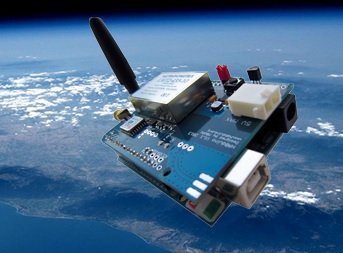
For tracking we used a SPOT tracker, and additional GPS tracker. We also were loaned a radio transmitting, the  HABduino board  with GPS module. When you receive it you just need to use a bit of software to change its call sign and frequency and then basically its ready to go. I should just explain that we were complete novices when it came to all things HAB, and all things radio. This bit of kit just works out of the box and Anthony was incredibly helpful in filling in the gaps for us – for example, we decided to mobile track our payload, so we downloaded (free) radio and decoding software. When we needed help to configure these, Anthony offered to remotely set them up over the internet for us!! So the HABduino is not only a radio tracker, but because you are then registered on the tracking servers, and if you advertise your flight on their notice board, you then have a whole community behind you on the day…which is a very good feeling!!

We purchased a FUNcube radio dongle and suitable antenna for mobile tracking, downloaded the relevant radio and decoding software and also started liaison with Anthony Stirk, the Habduino inventor, who was able to advise us further on the radio set up and get us up and running on the tracking website, and visible to the whole tracking community.

The day before the launch was spent building the payload – the logo, a laminated piece of card on the end of carbon fishing rod, with all other kit safely tied down inside the box. We devised a water tight system with last minute access to the cameras…and went to bed very late that night.

We rose the next day, checking the landing prediction software and weather reports. We’d arranged a site in Dorset for launch, and after having received our permission document from the CAA on the Thurs, we set out early on Sat 19th – myself and Richard, my partner in crime, plus our two sons and one of my daughters who was on video documenting duty.

We arrived at our launch site, a pub in Cashmoor, near Blandford Forum, only to decide that we were uncomfortable with the proximity of some low-level power lines. So we drove up a near-by hill and spied a suitable piece of land near a farm building and headed that way.

The farmer was out, but a neighbour kindly provided us with a mobile number and permission was obtained, so we started preparations, with the weather changing at speed around us.

Once the payload was rigged, tracking devices turned on and checked, we inflated the balloon and tethered it, before turning on the cameras and launching the 1000grm balloon. We were generally surprised by it’s rapid ascent. After a moment of pause in wonder…we then sprang into life, packing up and starting the chase. That first phase was a little chaotic, and it wasn’t really until making a garage stop, and getting re-organised did we really find our groove with the tracking. We always knew we were going to be at least an hour behind the balloon, so we did our best to plan a decent route, which involved us using an actual paper map!!

The actual chase was thrilling. My wife relayed us details from her tracking at home (we’d not planned this – she just got caught up in it!) and was able to help us speculate about possible landing sites around RAF bases. Infact we’d been given specific warnings about not landing in one base, as we’d been told we’d never see the payload again…and at one point, the predictor had it landing on one of the runways!!

It was amazing to watch the ascent…all the way to 3400m plus, and then see the icon on the tracker turn into a parachute as it begun it’s descent. Thankfully the payload missed the RAF base by a few hundred metres and landed in the middle of Thetford Forest…the only significant grouping of trees around for miles! But at least we knew it was accessible to the public. We were constantly receiving updates and ideas from Chris and Anthony via email and text and planned a route to get as close as we could to the payload.

WSMeteor

WSMeteor

Arriving at the forest, we switched to our netbook radio tracker and went mobile and found we could receive a signal almost immediately suggesting it wasn’t at ground level. One of our son’s spotted it, indeed not at ground level, but some 25 metres snagged in the top of a tall thin pine tree. After some head scratching, we approached a near by farm house and found a very generous hearted local farmer who drove his tractor into the forest to shake the relevant tree…which worked a treat, feeing  up the parachute and payload, allowing it to fall into another tree. At this point the daylight had faded, so we resigned ourselves to an overnight stay in a near by travelodge. The farmer had agreed to help us again in the morning, so when we returned to the site, there he was, with the payload under his arm!!

Can you spot the payload?

Can you spot the payload?

With some trepidation we unloaded the cameras (everything was well protected and in perfect condition, apart from the parachute which had a small hole in it from the tree) and reviewed the media onsite – much to the utter delight of the farmer – everything had worked exactly as intended. The video footage was amazing, and the still documented the entire trip, yielding some simply beautiful images.

We now have the bug and are already considering what our next project should be.

Many many thanks to Chris @ Balloon News for all his help and input, as well as Anthony Stirk.


BALLOON NEWS WEBSTORE BUY WEATHER BALLOON BUY PARACHUTE  HIRE SPOT TRACKER


New Satellite Segment in IARU Region 2 Bandplan

New Satellite Segment in IARU Region 2 Bandplan

source: http://amsat-uk.org/2013/10/22/new-satellite-segment-in-iaru-region-2-bandplan/

Following the IARU Region 2 (the Americas) meeting in September at Cancun, Mexico, the new Region 2 bandplans for all allocations from 137 kHz to 250 GHz have now been published.

There is a new allocation for the Amateur-Satellite Service from 144.000-144.025 MHz

There is also a reference to NSS – Near Space Stations in the definitions section. This is believed to be the first mention of High Altitude Balloons in any amateur radio band plan document. It says

NSS – Near Space Stations: Equipment located in temporary Near Space Stations (such as those carried by High Altitude Balloons) can transmit carefully on any frequency; exceptions are the segments with “exclusive” usage where “NSS” are not applied. NSS must follow the BW and mode restrictions of the segment and observe carefully the usual occupation of the band on the related region to avoid harmful interference. For longer missions and NSS crossing international and regional boundaries, extra care must be observed in harmonization of different allocations.

See the new IARU Region 2 bandplans at http://www.iaru-r2.org/documents/explorer/files/Plan%20de%20bandas%20%7C%20Band-plan/R2%20Band%20Plan%202013.pdf


BALLOON NEWS WEBSTORE BUY WEATHER BALLOON BUY PARACHUTE  HIRE SPOT TRACKER


RMetS East Anglia Meeting – Predicting the Weather for Felix Baumgartner’s Record Breaking Helium Balloon Ascent and Jump


Wednesday 13 November 2013 at 7.00 pm Predicting the Weather for Felix Baumgartner’s Record Breaking       Helium Balloon Ascent and Jump. Don Day, Chief       Meteorologist for Red Bull Stratos

            Most of you will remember back to October 2012             when Felix Baumgartner and his Red Bull Stratos team launched a             manned helium balloon to the edge of space. Felix then jumped out             from a record height of 24.2 miles above the Earth. He became the             first human to break the sound barrier outside of a vehicle (in             free-fall for 4 minutes and 29 seconds), reaching a speed of 844mph             on his way down.
What you may not know,             however, is the meticulous planning that went into the record             breaking jump, including the very tedious and difficult job of             forecasting the weather for the launch, which even had to be             cancelled once in the minutes leading up to launch. The Royal             Meteorological Society’s East Anglia Centre along with the             University of East Anglia have teamed up to invite Don Day, the             chief mission meteorologist for Red Bull Stratos, to give a talk             explaining everything that went into the planning and execution of             the mission from a meteorological standpoint.

              The talk will be             held at 7pm on Wednesday the 13th of November 2013, in the Thomas             Paine Study Centre Lecture Theatre at the University of East Anglia.             We also plan to stream the talk live on the internet, check http://www.rmets.org/about-us/local-centres/east-anglia-local-centre             a few days before the event for more details of how you can watch             the stream.

BALLOON NEWS WEBSTORE BUY WEATHER BALLOON BUY PARACHUTE  HIRE SPOT TRACKER

SPOT Gen 3 review update

The value of SPOT Messenger as a HAB weather balloon tracker is now well established. It’s simple operation features and robust design make it ideal as both a primary and secondary tracker. SPOT has now updated the Messenger with the GEN 3 so we have been running tests on it’s performance compared to the SPOT Messenger

—Track from SPOTs. Green – SPOT 2 Blue – SPOT Gen 3

—Track from SPOTs.
Green – SPOT 2
Blue – SPOT Gen 3

So far we have tested SPOT Gen 3 over 2 HAB flights in the UK; putting it head to head with the Messenger. The results show that the SPOT Gen 3 performs just as well, but no better than the Messenger in returning it’s location while attached to HAB flights. The Gen 3 offered a slight advantage  in it’s design as we found it easier to attach to the payload. The ‘sleep’ mode of the Gen 3, however, is a disadvantage as it gives some uncertainty to the location of a payload that has not yet been recovered. As yet though, there is no killer feature on the Gen 3 that should make you rush out and replace your trusted SPOT Messenger.

flight details –

Launch site – Oswestry

Landing Site  – Chase Golf resort, Staffordshire

Date 8th October 2013

Balloon – 1000gm PAWAN

Payload – SPOT Messenger, SPOT Gen 3, CATTRAQ, Go PRO Hero 2, Go Pro Hero 3,

TAG SPOT Gen 3 performs only as good as SPOT Messenger tracker in HAB Weather balloon flights.


BALLOON NEWS WEBSTORE BUY WEATHER BALLOON BUY PARACHUTE  HIRE SPOT TRACKER

A beginners guide to following a radio tracker on a weather balloon

Source http://www.essexham.co.uk/news/tracking-balloons-on-the-5th-of-may.html

By

Until recently, I knew nothing about High Altitude Balloon Tracking, until local amateur Chris Stubbs M6EDF got in touch via our Monday Night Net. As there were some balloon flights over the weekend, I thought I’d try and track them, and here’s how I got on…

Around the world, enthusiasts get together to let off helium-filled weather balloons with a payload of camera, GPS trackers and radio transmitters, and then use a network of trackers to plot the journey of the balloon, then pinpoint the landing site and retrieve the payload.

On Sunday the 5th of May 2013, two balloons were released from a location to the west of Cambridge, and I was able to track the second one very well. If you prefer watching to reading, here is a short video clip of my experiences:

4 Min Video: Tracking High Altitude Balloons

Signals from the balloons were on the 70cms band, but single sideband, so my standard rig couldn’t get the signals. So, I used an SDR, Software Defined Radio. The one I went for was my cheap-and-trusty Realtek RTL2832 dongle.  This costs around £10 and plugs into a computer or laptop USB socket. This was connected to my main 2m/70cm collinear on the roof.

Next – Software: I used the free package SDR Sharp – This package lets you tune into the correct frequency and set USB. Flights are announced on the ukhas.org.uk site, and frequencies are given. The flight I track,ed was using was on 434.244MHz – Here is what the signal looked like on the SDR# package. The two narrow bars are essentially packets of RTTY data.

Data received from a high altitude balloon

Data received from a high altitude balloon

Next, I used DL-FLDigi to decode the packets. It took a while to get the software to recognise the audio from the SDR, and some juggling to get everything working, but eventually, packets were being received and decoded.

Decoding balloon telemetry data using DL-FLDigi

Decoding balloon telemetry data using DL-FLDigi

Now the clever bit. On the website spacenear.us , there’s a realtime-tracker that shows the location of the balloon, based on uploads from spotters like me. My spots were appearing on the map showing the path of the balloon.

Tracking balloons using spacenear.us

Tracking balloons using spacenear.us

The various spotters, and the balloon owners, all hang out in an IRC chatroom, and a good dozen or so other folk were tracking the flight too. Following the balloons were the owners in a chase car, ready to recover the payload. The balloon I tracked covered a distance of around 12 mile due North over around 2 and a half hours, touching down between Peterborough and March. The tracking site shows altitude against time, and the eventual landing site, almost in a river.

The Xaben-1 balloon, almost landing in a river

The Xaben-1 balloon, almost landing in a river

It’s always fun to try something new radio-wise, and I’ll certainly be trying a little balloon tracking again. Well done to today’s balloonists, and thanks to Chris Stubbs M6EDF, owner of one of today’s payloads, called CHEAPO, for introducing me to this activity.


BALLOON NEWS WEBSTORE BUY WEATHER BALLOON BUY PARACHUTE  HIRE SPOT TRACKER

The lengths I go to, to recover my payload : sitting out the SHUTDOWN

Western Center Academy aviation lab teacher Christopher Read remains optimistic that his weather balloon equipment will be in good shape even though he can’t recover the devices from Joshua National Park until the federal government shutdown ends.

balloon-1-620x465

Students at the Hemet Unified School District’s charter school in the Western Science Center museum by Diamond Valley Lake launched the balloon Oct. 1, the day the shutdown due lack of a federal budget began.

The balloon rose to more than 100,000 feet, recording weather information along the way. As carefully planned, it exploded as the balloon expanded at high altitude, a parachute deployed and it returned to earth.

A GPS transmitter let the students know precisely where it landed in Joshua Tree National Park, which was about three miles off a road in the rugged desert. Read drove to the High Desert and was prepared for a cross-country adventure to make a recovery, but was turned away because the park was closed.

The GPS no longer is transmitting. Read, a seventh-grade English teacher at the science-based middle school, hopes to recover the equipment in good shape. Three more balloon launches are scheduled this year. The data equipment is worth about $1.000.

“I’m assuming it’s still resting comfortably close to where it landed,” he wrote.

“Our only exposed piece is the lens of the HD video camera. Everything else is fairly well protected from the elements inside the payload box. The camera is about $150, so that will be our max loss if we are able to retrieve everything else.

BALLOON NEWS WEBSTORE BUY WEATHER BALLOON BUY PARACHUTE  HIRE SPOT TRACKER

UKHAS announce Arctic HAB challenge

UKHAS laid down the gauntlet to HABists by posting the following challenge on their message board.
arctic map
“Inspired by the recent advances in high altitude ballooning I’ld like to introduce the Arctic Challenge. This is a challenge open to launch a balloon/payload from the UK that crosses the Arctic Circle before the next UKHAS Conference.
The challenge will require both development of a payload, launching a floating balloon but also the ability to receive the data confirming it has crossed the Arctic Circle.
There is a prize for the first person to complete this challenge, obviously eternal glory but also a trophy and a cash prize.
For more information see the wiki page (http://ukhas.org.uk/ukhas:arctic_challenge) or get in contact. The rules may still develop over the next weeks and I’m open to suggestions of how to develop the challenge further.
Thanks
James M6JCX”

BALLOON NEWS WEBSTORE BUY WEATHER BALLOON BUY PARACHUTE  HIRE SPOT TRACKER