First there was Pi. Now there is Choco Pie for HAB High Altitude Balloons

Source

http://www.usatoday.com/story/news/world/2014/07/31/south-korea-choco-pies-north-korea/13414039/

http://www.theguardian.com/world/2014/jul/30/south-korean-activists-choco-pie-balloons


chocopi1


South Korean activists launch ‘Choco Pie’ balloons

Choco Pies – banned as a capitalist symbol by North Korea after being traded at inflated prices – carried in balloons across border.
chocopi2

South Korean activists have launched balloons across the border withNorth Korea carrying thousands of Choco Pies – a favoured chocolate snack that has become the target of a reported crackdown.

About 200 anti-Pyongyang activists released 50 helium balloons carrying 350kg (770lbs) of snacks, including 10,000 Choco Pies, from a park in the border city of Paju, organisers of the event said.

The humble Choco Pie – a confection of chocolate-coated cake and marshmallow – has become an oft-referenced footnote in the volatile history of inter-Korean ties.

Offered as perks to North Koreans working in South Korean factories in the Kaesong joint industrial zone, Choco Pies spawned their own black market and were traded on at sharply inflated prices.

chocopi3

According to media reports in Seoul, the emergence of the South Korean snack as an unofficial currency became too much for the authorities in Pyongyang, who in May ordered the factory owners to stop handing them out.

“Embarrassed by the growing popularity of Choco Pie, North Korea banned it as a symbol of capitalism,” said Choo Sun-Hee, one of the organisers of Wednesday’s balloon launch.

“We will continue to send Choco Pie by balloons because it is still one of the most popular foodstuffs, especially among hungry North Koreans,” Choo told AFP.

South Korean activists regularly launch balloons, usually carrying anti-Pyongyang leaflets, across the border.

Pyongyang has repeatedly pressed Seoul to stop the activists and threatened to shell the launch sites.

The Choco Pie stunt is not an isolated incident. In 2008 South Korean peace activists used helium balloons to send information pamphlets from the south to people in the north. The activists used similar plastic balloons and sophisticated release mechanisms.


http://news.bbc.co.uk/1/hi/world/asia-pacific/7719755.stm

Pi In The Sky Telemetry Board Released

Source www.daveakerman.com


High Altitude Ballooning is an increasingly popular hobby (I nearly said that interest has been “ballooning”, but fortunately I stopped myself just in time …), bringing what is termed “near space” within the reach of pretty much anyone who is willing to put in the effort and spend a moderate amount of money.

cropped-moon-and-sky-web

Although it’s possible to successfully fly and retrieve a balloon with a simple GSM/GPS tracker, the chances are that this will end in failure and tears.  GSM coverage in the UK is nowhere near 100% especially in rural areas which is where we want (and aim) the flights to land.  The next step up, in reliability and price, is a “Spot” tracker which works solely via satellites, but those don’t work if they land upside down.  Also, neither of these solutions will tell you how high the flight got, or record any science data (e.g. temperature, pressure), or indeed tell you anything about the flight until they land.  If you’re lucky.  A lost flight is a sad thing indeed.

Still-1

For some countries (e.g. USA, but not the UK), if you are a licensed amateur radio operator you can fly an APRS tracker, in which case the flight will be tracked for you via the ground-based APRS network run by other radio hams.  Sadly UK laws prohibit radio hams transmitting from an airborne vehicle, so APRS is out for us.

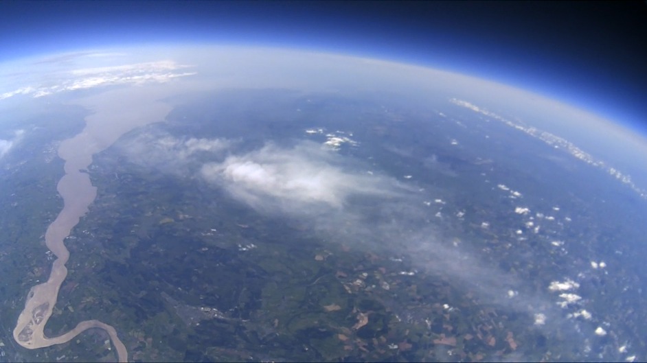
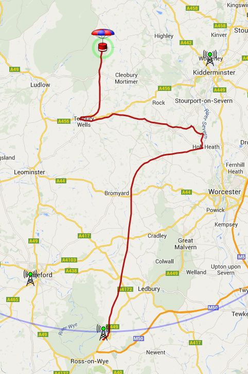
For these reasons, pretty much everyone involved in the hobby in the UK, and many other countries, uses radio trackers operating in an ISM (Industrial. Scientific and Medical) band where airborne usage is allowed.  These work throughout the flight, transmitting GPS co-ordinates plus temperature and anything else that you can add a sensor for.  Many radio trackers can also send down live images, meaning that you can see what your flight is seeing without having to wait for it to land.  Here’s a diagram showing how telemetry from the flight ends up as a balloon icon on a Google map:

system

What’s not shown here is that, provided you tell them, the other balloonists will help track for you.  So not only will you be receiving telemetry and images directly via your own radio receiver, but others will do to.  All received data is collated on a server so if you do lose contact with the flight briefly then it doesn’t matter.  However, this does not mean you can leave the tracking up to others!  You’ll need to receive at the launch site (you have to make sure it’s working!) and also in the chase car once it lands.  The expense of doing this is small – a TV dongle for £12 or so will do it, with a £15 aerial and a laptop, ideally with a 3G dongle or tethered to a phone.

Traditionally, balloonists build their own radio trackers, and for anyone with the skills or the time and ability to learn programming and some digital electronics, this is definitely the most rewarding route to take.  Imagine receiving pictures of the Earth from 30km up, using a piece of kit that you designed and built and programmed!  So if you are up to this challenge (and I suspect that most people reading are) then I recommend that you do just that.  It takes a while, but during the development you’ll have plenty of time to research other aspects of the hobby (how to predict the flight path, and obtain permission, and fill the balloon, etc.).  And when you’re done, you can hold in your hand something that is all your own work and has, to all intents and purposes, been to space.

Burst-1-1024x571

For some though, it’s just not practical to develop a new tracker.  Or you might be a programming whizz, but not know which end of a soldering iron to pick up.  It was with these people in mind that we (myself and Anthony Stirk – another high altitude balloonist) developed our “Pi In The Sky” telemetry board.  Our principle aim is to enable schools to launch balloon flights with radio trackers, without having to develop the hardware and software first.  It is also our hope that older children and students will write their own software or at least modify the provided (open source) software, perhaps connecting and writing code for extra sensors (the board has an i2c connection for add-ons).

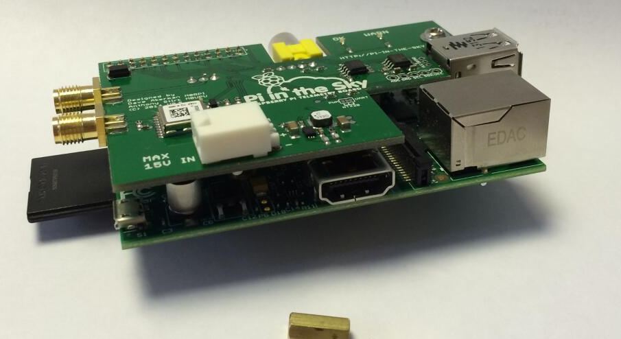
The board and software are based on what I’ve been flying since my first “Pi In The Sky “flight over 2 years ago, so the technology has been very well proven (approximately 18 flights and no losses other than deliberate ones!).  So far the board itself has clocked up 5 successful flights, with the released open-source software on 3 of those.  Here’s the board mounted to a model B (though we very strongly recommend use of a model A):

pits (1)It comes in a kit complete with a GPS antenna, SMA pigtail (from which you can easily make your own radio aerial), stand-offs for a rigid mounting to the Pi board, and battery connectors.  Software is on https://github.com/piinthesky, with installation instructions at http://www.pi-in-the-sky.com/index.php?id=support, or there is a pre-built SD card image for the tragically lazy.  We do recommend manual installation as you’ll learn a lot.

By now you’re probably itching to buy a board and go fly it next weekend.  Please don’t.  Well, buy the board by all means, but from the moment you decide that this is the project for you, you should task yourself with finding out all you can about how to make your flight a safe success.  For a start, this means learning about applying for flight permission (which, if you want to launch from your garden at the end of an airport runway, isn’t going to be given).  Permission is provided together with a NOTAM (NOtice To AirMen) which tells said pilots what/where/when your launch will be, so they can take a different path.  You also need to learn about predicting the flight path so that it lands well away from towns or cities or motorways or airports.  I hope I don’t need to explain how important all of this is.

IMG_0690

There’s lots more to learn about too, for example:

  • How to track the flight
  • How to fill a balloon
  • Where to buy the balloon
  • What size balloon?  What size parachute?  How to tie it all together?

None of this is complicated (it’s not, ahem “rocket science”), but there is a lot to know.  Don’t be surprised if the time between “I’ll do it!” and “Wow, I did it!” is measured in months.  Several of them.  In fact, worry if it’s less than that – this research takes time.  We will be producing some teaching materials, but meantime please see the following links:

As for the board, it provides a number of features borne out of a large number of successful flights:

  • Efficient built-in power regulator providing run time of over 20 hours from 4 AA cells (using a model A Pi)
  • Highly sensitive UBlox GPS receiver approved for altitudes up to 50km
  • Temperature compensated, license-free (Europe) frequency agile, 434MHz radio transmitter
  • Temperature sensor
  • Battery voltage monitoring
  • Sockets for external i2c devices, analog input, external temperature sensor
  • Allows use of Raspbery Pi camera
  • Mounting holes and spacers for a solid connection to the Pi

The open-source software provides these features:

  • Radio telemetry with GPS and sensor data using UKHAS standard
  • Radio image download using SSDV standard
  • Multi-threaded to maximize use of the radio bandwidth
  • Variable image size according to altitude
  • Stores full-definition images as well as smaller transmitted images
  • Automatically chooses better images for download
  • Configurable via text file in the Windows-visible partition of the SD card
  • Supplied as github repository with instructions, or SD card image

Finally, anyone interested in high altitude ballooning, using our board or not, should come to the UKHAS Conference on 16th August 2014 at the University of Greenwich.  Anthony and I will be presenting our board during the morning sessions, and will run a workshop on the board in the afternoon.  For tickets click here.

Posted in Weather Balloon | Leave a comment

Pi In The Sky Project – Successful Test Flight

This was the third flight of the “Pi In The Sky” board, but the first flight of the new open-source software written specifically for it (previous flights used a modified version of my usual Pi tracker software). The new software is a single multi-threaded program (instead of a collection of separate programs) and is configured via a text file so that for most users no recompilation is needed.

For this flight I used a foam polystyrene egg bought from HobbyCraft. The Pi and tracker board fit neatly inside one half:

IMG_0690

whilst the camera, GPS antenna and battery pack fit inside the other. No other packing was needed and the 2 halves were glued together with UHU Por polystyrene adhesive. Here’s the result:

IMG_0689


The glue is strong, but just to make sure I put some tape around the egg to keep the halves together.  Here’s the resulting payload, as I start to inflate the balloon:

IMG_0554


The launch was easy, and we watched for a while as the flight broke through the clouds and started to download some nice images, after which we set out to chase.  We were expecting the flight to land east of Ludlow, and we initially stopped near Leominster till the balloon turned west, then nearer Tenbury Wells as we waited for the burst.  That happened at 31644 metres, nearly 2km above the calculated figure, and pretty good for a 500g balloon.  Here’s the full flight path:

1

We were about 3 miles away when it landed, which isn’t bad considering the narrow winding roads in the area.  Landing spot was 4.5 miles from the prediction which is also pretty good.  Once it landed we headed for the last position, and when about half a mile away we received a signal strong enough to decode.  We then had the final position which was near a farmhouse:

2

We parked up and spoke to a farm worker and then the farmer who was very helpful, allowing us to wander round trying to find the payload.  Initially we went to the wrong place, having transcribed the co-ordinates wrongly!  So we went back to the car, got the correct position, and checked the view from the payload’s camera which the farmer recognized:

small_445

Once we had that information it only took a couple of minutes to locate the flight, which was on the ground with the line going over a bush.

So, a successful first flight for the new software and third flight for the new board.  There’ll be another test flight soon, hopefully next weekend.  Meanwhile, some photos from the flight:

medium_245

medium_238

HAB flight for all in one Raspberry Pi tracker, camera, and locator

Andrew Huff, student at The Grammar School Leeds, has shown how the Raspberry Pi cut down computer can be used for an all in one offline tracker, camera, and GSM locator for high altitude balloon flights.

Andrew picks up the story in his own words.

Six months ago, after being fooled by the “free computers” sign on my
computing teachers door and receiving a credit card sized Raspberry Pi
computer, I then had to prove myself to be “worthy” of receiving this
£20 Linux PC. So, no sooner said than done I decided to take on the
daddy of all Pi projects – to send it up 90 thousand feet into near space.

I’ve seen the photos countless times before, a cloud covered sphere with
a thin blue haze, glowing against the backdrop of space and yet I still
wanted to replicate it myself to see if this weird, soundless place
really did exist for someone like me, who doesn’t usually receive NASA
funding. Better still, to be able to reach this place with something
which I made and understand myself, captivated me and so from this point
on, I set out to create and program a Raspberry Pi which would be
capable of recording flight data, taking photos and most importantly
being able to send me its position afterwards so that I could collect it.

David Ackerman, the first person to use a Pi for high altitude
ballooning and the many other micro-controllers which preceded mine, all
used armature radio to track down and receive data from the payload. The
benefits of using radio to track the Pi would be that I would be able to
follow it for the entire period that it is in the air and the coverage
is allot better than the patchy GSM network which I settled upon using.
However, as I found out, understanding and then using radio to track the
Pi is allot more complex than just sending an SMS though a mobile dongle
so I soon settled on using that instead.

andrew pi

The next problem came from having to interface with the GPS module.
Before I started this project, all my programming experience was writing
small space-invaders games in BBC BASIC and so having to send binary
and hex commands to an external device was a real shock, which took me a
few days and allot of headaches to figure out. The good news though, is
that after I finally cracked it, I had a much deeper understanding of
how and why the technology worked which was a far cry from the “copy and
paste someone else’s code” approach which I honestly thought this
project would be at the beginning.

As the project grew in complexity, so did my ambitions and so I decided
to add a thermometer to the Pi to see just how cold it gets up there
(and FYI. the pilot isn’t lying when he announces that it’s -50 outside
the aircraft). Although simple to code, the thermometer taught me
another important life skill which was soldering – my new favourite way
of joining anything! All the information on how to do this was readily
available online and it’s well worth doing since it leaves you with a
warm, glowing sense of accomplishment inside, that what you have just
fused together will never ever fall apart. (Just kidding, I’m not that
strange 🙂

Finally, came launch day. Chris and I set up our equipment and after
filling the balloon and giving an on the fly briefing to our small crowd
of spectators, I let it loose to ascend into that mysterious world which
I first was hooked by over six months ago. I was nervous yet at the same
time proud and satisfied that something which I built was hanging there,
in Arctic temperatures and in an atmosphere one twentieth of what I was
in at that time, beeping and flashing away all on its own, suspended
above a 26km plummet to the earth. But of course, it wouldn’t stay that
way for long. After the inevitable “pop” the real action took place and
as we raced across Yorkshire and Lancashire, finally came the
“ba,da,ding” from my phone which I was praying for. We drove to the last
known location and sure enough, Chris spotted the payload in the middle
of a field between two power lines and a wood. Unfortunately, on impact
the Pi had disconnected its self from the power and so that’s why in
actual fact, we ended up using the backup tracker to pinpoint its
precise landing spot. However, none of this really mattered because in
the end I had proved to myself that I was able to get into near space
and back again using only my year and a half’s computing GCSE course and
a £20 PC.

IMG_2903

But that’s only half of the storey, this project went allot deeper than
just computing. I had to organise CAA permits, secure landowner
permission, talk to Professors, convince the school’s marketing
department to fund me and finally be lucky enough to get in touch with
Chris who helped me an indescribable amount to shape the project into
what it has successfully become. In total, what had started off as a small computing idea, has grown into an irreplaceable learning
experience with far reaching benefits for a sixteen year old student
like me.

Irish Sea

Which is the best SPOT tracker for your HAB – weather balloon flight?

 spot 1

There was a time when you only had one choice when using SPOT as a tracker for your HAB flight. Then came the ever popular SPOT messenger and, along with the rise of action cameras, the hobby of HAB grew and grew. Now there are a plethora of SPOT devices to tracker your HAB flight including the GEN 3 and Trace. But which is best for your HAB flight?

SPOT Messenger (blue) and SPOT Trace (orange)

SPOT Messenger (blue) and SPOT Trace (orange)

In a recent flight I used both the SPOT Trace and Messenger. Due to unforeseen circumstances the payload twisted to point to the horizon (and not straight up) so the results are unexpectedly good. The results from the SPOT Trace, which was recording payload location every 5 minutes, was very impressive. This has inspired me to test all the SPOT trackers on one flight. More details of the test will be posted closer to launch date.

High Altitude Ballooning causes less damage than the Telegraph article would suggest

While writing a blog post on the ways HAB flights can go wrong, I came across an article by the Telegraph news paper on the cost of Met Office radiosondes landing and damaging people’s property.

http://www.telegraph.co.uk/news/uknews/7841724/Met-Office-apologises-after-weather-balloon-crashes-into-conservatory.html

The figure of £25,000 worth of damage to 2010 seemed alarmist so I did some digging.

Data released to me by the Met Office under a  FOI request suggests that high altitude ballooning is a low impact hobby. I asked the Met Office for information on insurance claims made as a result of their radiosonde programme during the years 2010 to the start of 2014. This is the response I got.

“No claims have been submitted to insurers during the financial years 2010/11 to
2013/14. The excess on our insurance policy is £5,000. We have had a small number of
low level claims made to us directly during the period, relating to matters such as, the
retrieval of sonde balloons caught in trees (various), one caught on a power line (2010),
one case of damage to a roof tile (2011) and one case of ingestion by farm livestock
(2012). The maximum cost of these claims was £200.”

Given that the the frequency of high altitude balloon flight by the Met Office is much greater than the hobby community, we can assume that the amount of claims from hobbyists and the science community is much less. While I don’t have any data from hobbyists, I am happy to assume that the impact of HAB as a hobby is much less than the Met Office radiosonde programme.